https://www.youtube.com/watch?v=I2qluSQDdGw
【Weather on 30th】 Autumn Rain Front which separates the season
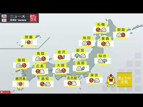
30日の朝は本州付近に秋雨前線が停滞している。前線の北側にあたる札幌や青森は秋のさわやかな空気に包まれる。前線がかかる仙台や新潟は雨。前線の南側は夏の蒸し暑い空気で晴れる所が多いが、大気の状態が不安定で、太平洋側の地域もにわか雨や雷雨に注意が必要。
予想最高気温は札幌が23℃でこの時期らしい陽気に。仙台も23℃だが前日よりも大幅に低く、雨で涼しく感じられそうだ。東京は32℃、広島は34℃まで上がり、高知や鹿児島は35℃と猛暑日の予想。
The autumn rain front is stagnating near Honshu in the morning of the 30th. Sapporo and Aomori at the north side of the front line are wrapped in refreshing air of autumn. It is rainy in Sendai and Niigata where the front line is taken. The southern part of the front line is sunny and humid in the summer, but there are many places to sunny, but the state of the atmosphere is unstable, and the region on the Pacific side also needs attention to showers and thunderstorms.
The anticipated highest temperature is Sapporo at 23 ℃ and it seems like this season. Sendai is also 23 degrees Celsius but it is much lower than previous day, it seems to be cooler in the rain. Tokyo is 32 ℃, Hiroshima rises to 34 ℃, Kochi and Kagoshima are predicted 35 ℃ and hot summer day.
——————————————————————————————-
– Subscribe to a Channel thank you
– あなたのチャンネルを感謝購読


最近のコメント